Report on Trip to Madagascar and Tanzania (November 16 to December 4, 2016)
Kyoto University
Professor of The Center for African Area Studies
Jun IKENO
I traveled to Madagascar and Tanzania from November 16 to December 4, 2016. In Tanzania, my primary destination was Unguja (henceforth: Zanzibar), the main island of the Zanzibar Archipelago in the Indian Ocean. Apparently, few travelers travel to these two destinations, so it was difficult to organize the itinerary. In the end, this was my route:
Nov. 16 11:40 pm Departure from Kansai International Airport
Nov. 17 5:05 am Arrival in Dubai
10:25 am Departure from Dubai
4:18 pm Arrival in Johannesburg (South Africa)
10:08 am Departure from Johannesburg
2:00 pm Arrival in Antananarivo (Madagascar)
Nov. 25 4:52 pm Departure from Antananarivo
7:54 pm Arrival in Nairobi (Kenya)
11:58 pm Departure from Nairobi
Nov. 26 1:20 am Arrival in Zanzibar (Tanzania)
Dec. 2 10:32 am Departure from Zanzibar
10:55 am Arrival in Dar es Salaam (Tanzania)
Dec. 3 5:25 pm Departure from Dar es Salaam
11:18 pm Arrival in Dubai
Dec. 4 3:45 am Departure from Dubai
5:03 pm Arrival at Kansai International Airport
To reach Zanzibar on November 26, I considered routes via South Africa, Zambia, or Mauritius but finally decided to take the connection with the earliest arrival time in Zanzibar via Nairobi. Since the arrival time was after midnight on the 26th, I expected the flight to be mostly empty; however, there were about 20 passengers who got off at Zanzibar, including who appeared to be Western tourists and Africans who lived in Zanzibar. The flight was also continuing on to Kilimanjaro (Tanzania) after Zanzibar; hence, a fair number of passengers remained on the plane.
1. Madagascar
One of my objectives of visiting Madagascar on this trip was to meet Professor H. Rakotomanana of the Department of Zoology and Animal Biodiversity, Faculty of Sciences at the University of Antananarivo, to discuss on the project “Network Formation for Reconstructing the Paradigm of African Area Studies in a Globalizing World”, and to reaffirm our commitment to continue working cooperatively in the future. I was able to meet with Prof. H. Rakotomanana in his office on November 24. I was also able to meet Prof. F. Rakotondraparany and Prof. Z. Rakotomalala, the department chair; we had a meaningful discussion on making mutual efforts to facilitate each other’s research and promote collaborative research further (Photo 1).
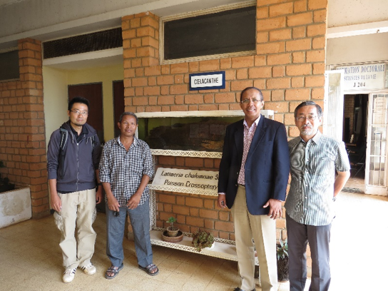
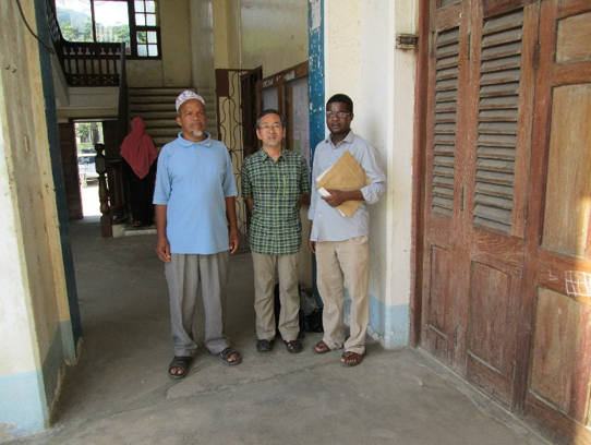
Photo 1: In front of a coelacanth specimen displayed at the University of Antananarivo
(November 24, 2016)
From right to left: myself (Ikeno), Prof. Rakotomanana, Prof. Rakotondraparany and Dr. Shin’ichirō Ichino
Another objective was to broaden my knowledge of the ecological conservation in Madagascar, which has a unique ecosystem in Africa. I asked Dr. Shin’ichirō Ichino (Center for African Area Studies, Kyoto University), a researcher who had been sent to Madagascar as part of this program, to accompany me. We visited Andasibe-Mantadia National Park, which is about a three-hour drive east of Antananarivo, on November 19 (Photo 2). Then, from November 20 to 23, together with Dr. Hiroki Sato (Center for African Area Studies, Kyoto University), I, Shin’ichirō Ichino, and others visited Ankarafantsika National Park (about 400 km north of Antananarivo, eight hours by car), which is Dr. Sato’s research area (Photos 3 and 4). We were able to walk on foot through the national parks that we visited on this trip, and enter the forest if we spotted any lemurs. This regulation of national parks was quite different from what I had experienced thus far in national parks in Tanzania and Kenya. In these East African national parks, because of the presence of beasts of prey, such as lions, and the efforts to preserve the vegetation of the savanna, people generally travel through the parks in vehicles. These vehicles are not allowed to drive off-road, and as a general rule, passengers are not permitted to exit the vehicles. Moreover, most national parks in East Africa are surrounded by luxurious hotels and souvenir shops, whereas I found that the areas around national parks in Madagascar had a more relaxed atmosphere, with fewer tourists.
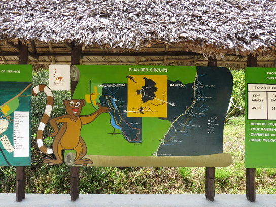
Photo 2: Information board at the entrance of Andasibe-Mantadia National Park (November 19, 2016)
The board shows a selection of routes with varying walking times, so visitors can choose their own route according to their own physical ability and the amount of time they would like to spend, and are then led through the park by an authorized guide.
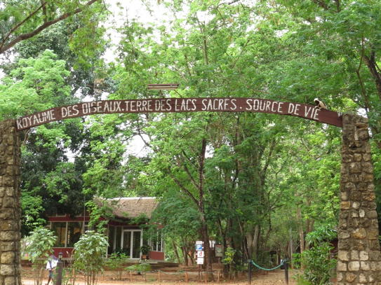
Photo 3: Entrance to Ankarafantsika National Park (November 21, 2016)
Written on the arch are the indicative words: “KINGDOM OF BIRDS・LAND OF SACRED LAKES・SOURCE OF LIFE.”Sitting atop the final letter is a sifaka (a genus of lemur that inhabits Madagascar).
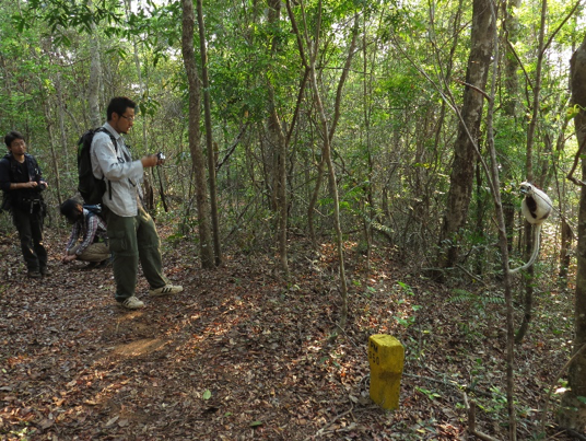
Photo 4: A chance encounter with a sifaka (Ankarafantsika National Park, November 22, 2016)
Dr. Ichino photographs the sifaka at the far right of the picture.
Perhaps it recognizes humans as harmless;even at a close range, it did not run away.
What especially impressed me of the landscape on the way to the two national parks from Antananarivo was, first, the large number of water-filled paddy fields (Photo 5). In contrast, there seemed to be a limited number of annual crops and tree crops. Driving for three or eight hours in
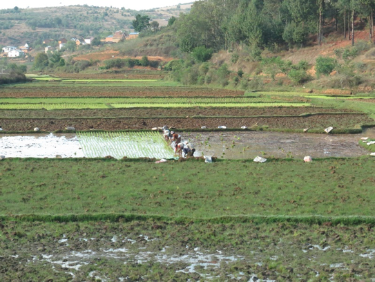
Photo 5: View of rice fields along the roadside (November 19, 2016)
Water-filled paddy fields abound en route to the two national parks to the east and north of Antananarivo.
Kenya or Tanzania in East Africa, quite a variety of crops can be seen. However, purely in terms of crops, I found the scenery in the areas of Madagascar that I visited on this trip rather plain. There are more than a few areas with endless grassy plains and no houses in sight. Eucalyptus and pine trees have been planted in some areas, but many of the trees and bushes have been burned (Photo 6). Eucalyptus and pine trees are used as building materials and fuel but, here, they seemed to have been damaged at the developmental stage. As for houses, as we moved closer to Ankarafantsika National Park, the two-story style, with an attached veranda, that is popular among the Merina people on the outskirts of Antananarivo (Photo 7) gave way gradually to the style typical among the Sakalava people (Photo 8), with rafters on the roofs and protruding eaves.
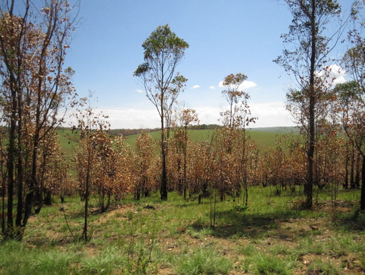
Photo 6: Eucalyptus trees charred from field-burning, but still alive (November 23, 2016)
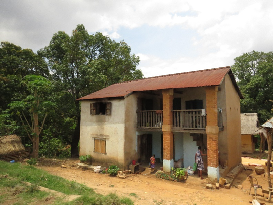
Photo 7: A house on the outskirts of Antananarivo (November 20, 2016)
Two-story brick houses with verandas are not found in my research areas of northern Tanzania.
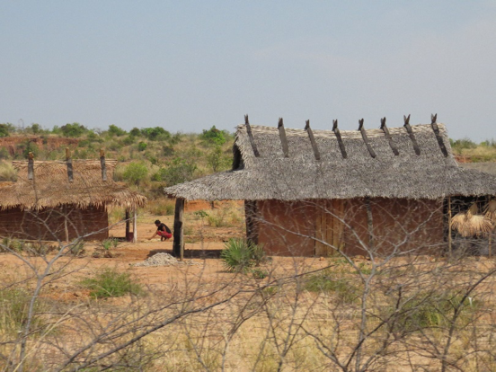
Photo 8: A house with rafters on the roof and protruding eaves (November 23, 2016)
This style of house is typical among the Sakalava people who populate northern Madagascar.
2. Tanzania (Zanzibar)
I left Antananarivo on November 25, had a connecting flight in Nairobi, Kenya, and arrived in Zanzibar, Tanzania in the early morning of 26. I had two main reasons for visiting Zanzibar, Tanzania, which is not including into the counterpart countries of this program. The first was to exchange ideas with local researchers with the aim of deepening our cooperation in the future. Second, similar to Madagascar, Zanzibar is in the west Indian Ocean but has a more developed tourism industry than Madagascar; thus, I aimed to gain an understanding of the current situation in Zanzibar, particularly gain knowledge on the living environment of local residents.
As per the first objective, I met with Prof. Mohammed Ali Sheikh of the State University of Zanzibar (SUZA) with whom I was already acquainted; I explained this program to him and we agreed to plan a similar program in Tanzania, including Zanzibar (Photo 9). Incidentally, SUZA’s name in English begins with the words “State University.” If this were an American university, it would be appropriate to translate the name into Japanese as Shūritsu Daigaku (State University); however, because of the special circumstances of the United Republic of Tanzania, it is preferable to translate it as Kokuritsu Daigaku (National University). The country is composed of the mainland portion (on the African continent) and the Zanzibar Archipelago in the Indian Ocean, each with different histories of colonization. Even after the two parts merged in 1964, Zanzibar has maintained internal autonomy, including the educational sector. SUZA was established by the Revolutionary Government of Zanzibar, and although not under the jurisdiction of the United Republic of Tanzania, it is recognized as a national university. SUZA is a new university that was established in 1999 and began running in 2001. I met Professor Sheikh at SUZA’s Vuga campus, which is located in Stone Town, a World Heritage Site. This campus, dating from when SUZA was first founded, has become rather cramped, so SUZA’s main campus has already been moved to Tunguu in the suburbs. SUZA’s faculty members are also generally young. Professor Sheikh is in his early 40s, but he already holds the important position of directorship of the Center for Graduate Studies and Research. Professor Sheikh is also in a position where he can advise the Zanzibar government about all matters related to research activities in Zanzibar, and I will likely request his cooperation on various matters related to research on Zanzibar.
Photo 9: State University of Zanzibar (SUZA) (November 29, 2016)
One might think that Prof. Sheikh is the person on the left, but in fact, he is the person on the right. The person on the left is Mr. Hassan R. Ali, who has recently completed his graduate studies. Mr. Ali was Prof. Sheikh’s teacher in elementary school; he entered graduate school at SUZA several years ago and has now become the apprentice of Prof. Sheikh, his former student.
My other objective in visiting Zanzibar was to gain some sort of knowledge about the living environment. In the past, I had visited Zanzibar to collect samples to test the quality of well water, traveling around to approximately 100 wells on Unguja Island; it was Mr. Ali (Photo 9) who accompanied me. To find out if there had been any changes in the landscape in the two years, I traveled the wide area of Unguja Island for a second time (see map).
The coastline south of Unguja’s north tip and central east coast are bristling with resort hotels for foreign tourists. Areas, where no buildings have been constructed, are also surrounded by fences; there are long stretches of empty spaces extending along the coastline where people cannot enter. Perhaps because most of the areas facing the coast have been filled up, hotels are now springing up on the west side of the road along the coastline (that is, on the other side of the road and the coastline). The local residents who have provided the land for these hotel sites (it is unclear whether the land was sold or rented out) are continuing to build houses farther away from the coast. The transformation of the east coast into resort areas is also progressing steadily along the coastline north of the central region. Finding a compromise between the livelihood needs of local residents, such as fishing and collecting marine products on the shore, on the one hand, and the hotel industry and the development of marine sports geared toward foreigners on the other, is becoming increasingly problematic (Photo 10).
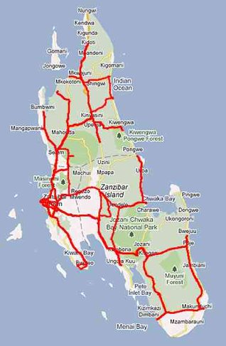
Map: The roads I used on Unguja Island (roads traveled indicated in red)
The scale is not shown on the map, but Unguja Island is 1,658 km2, slightly smaller than Osaka prefecture (which is 1,905 km2, the second smallest prefecture in Japan).
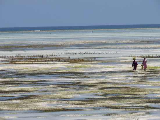
Photo 10: A shallow beach in Paje, on the southern part of the Unguja Island’s east coast
The two women on the right are carrying seaweed that they have collected. The small stakes that can be seen to their left are for seaweed cultivation. Resort hotels line the area to the right of the women (not shown in the picture), and marine sports are popular.
Compared with the east coast, where the tourism-related development is already in progress, the inland area and the west coast are mostly farmland, with the exception of the urban area of Stone Town. The pace of development feels slow, but the establishment of road networks has progressed in the past two years. Two years ago, the road going west from Stone Town was one lane in either direction, but a two-lane road has been newly constructed, and may be extended further. The evictions from buildings along the road that have resulted from this process have been a headache for local residents (Photo 11).
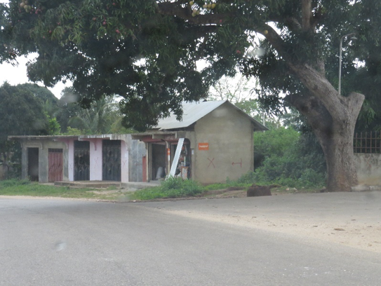
Photo 11: A shop wall is marked with an X and an arrow, showing that a portion of the building must be demolished to make way for the widening of the road. The portion that must be demolished is everything to the left of the arrow, about 80% of the building.
3. Reflection
Having the opportunity to visit Madagascar for the first time, I was able to experience a different Africa from the inland areas of east Africa (eastern Kenya and northern Tanzania) that I have been studying for 40 years. However, I also noticed certain commonalities between Zanzibar and Madagascar, such as the islets, the rice-based culture, and the development of the tourism industry, which are likely a result of their similar backgrounds. Although geopolitical and political economy analyses have already been undertaken by writers such as Robert D. Kaplan (Kaplan, Robert D., Monsoon: The Indian Ocean and the Future of American Power, Brandt & Hochman Literacy: New York 2010), the analytical spaces and frameworks focusing on cultural issues, can also provide clues for the paradigm shift for which this program is aiming